A report spreads for decades but makes no sense. How intriguing and frustrating. In a newspaper column from (unconfirmed date) April, 1919, Edward Morphy says that the lake in my neighborhood was destroyed by the 1862 storms with which I am so intrigued. But the detail given makes absolutely no sense. Says Morphy:
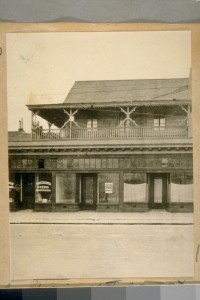
…probably the best known landmark of Divisadero street in the pioneer days was the old San Souci roadhouse which stood on the east side of a pretty little lake that then filled the space from Fulton to about midway between Hayes and Fell streets.
(The roadhouse was at the location of the current pet salon at 1333 Fulton Street.)
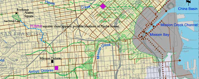
One night in the winter of 1861-’62—the wettest San Francisco had ever known—the lake overflowed its sandy banks and the water rolled down the valley and into the Mission, cutting its channel ever deeper as it went. In the morning there was only a fraction of the old lake left and the glory of San Souci had materially departed.
The blue dotted line is the approx. path an overflow must have taken, passing the Page Street dune through a gap at what is now Fillmore Street. The purple squares are approximate Pioche home locations. The existence of a “San Souci Lake” is based only on the one source: Morphy. It’s shape is interpolated from the 1859 Coast Survey map.
Morphy goes on: But, down in the valley, in the beautiful block bounded by Seventh and Eighth streets. Mission and Howard, the basin that had formed the lovely gardens of the Pioche home was a sea of water. In its center, with only the cupolas and the roof and part of the second-story visible…
And, in fact, I’ve seen a photo claiming to be “Pioche’s Pond” with the house in deep water—I cannot recall where, but I believe I could find it again.
Morphy’s description of the event is repeated (with or without attribution) in many locations, including in various books, and everyplace from the California Historical Society’s card catalog to an article a few months ago in the Alamo Square Neighborhood Association newsletter. (Look in the right column on the page after the roadhouse photo. Note the doubly inaccurate phrase “Francis Pioche family.” His name was Francois, and he had no family. It was believed and apparently accepted that he lived with his male lover.)
Yes, history is becoming easier than ever to research and serve to the neighbors.
The only problem is that it’s impossible. The block on Mission between 7th and 8th Streets lies in an entirely different watershed from the one San Souci occupies, and it’s not in the “Mission” as claimed. Unless a tunnel existed through Alamo Square into Hayes Valley, the described flooding could not have reached to that property.

Pioche was a lesser-known but major influence in San Francisco. Perhaps his suicide or homosexuality reduced interest in him by period biographers.
As it happens, I’ve seen records of at least three different properties owned by Pioche (Warning: Numerous details in the linked biography are incorrect, as you’ll see just by the storm date given). Pioche’s business location at Clay & Montgomery, may have been owned by him and he seems to have owned dwellings at 806 Stockton, on Dolores just south of the Mission itself, and the block mentioned above, at Mission and 7th.
Could it have been his home on Dolores that was flooded? Perhaps, but the scant and questionable information I’ve found as to its location said it was a short distance south of the Mission Dolores, which would put it just beyond the reach of a flood coming down San Souci Valley…unless the flood was so strong as to surge over the farmed rise upon which the Mission itself sits. Not impossible.
The Dolores location seems to have been sometimes called Pioche’s “Hermitage.”
If you are inclined to investigating mysteries, I’d welcome your participation in this. My friend and neighbor, Chris Dichtel, has found that there were court cases about property damage relating to this flood of water from San Souci Lake. If you want to dig in deeper, let me know and I’ll give you all the (few) other details I have, along with ideas of how to get more. I’d save the fun of discovery for myself, but I have a heap of other stuff pulling on me at the moment. Of course, if you discover the answer, I’ll quote and credit you, and probably cook dinner for you, too!
Interesting, you’re already saying, how water from a storm, after passing through a lake, becomes known as water “from” that lake. Right? Morphy again:
Some time after the San Souci lake overflowed its banks in 1862 and created the Pioche pond in the Mission, a family named Bulger [don’t trust spelling, as it’s from OCR] moved out that way and made their home near the gap cut by the flood water.
Somehow I don’t think the gap referred to was a gap in the huge serpentine rock ridge between San Souci and Hayes valleys! The gap must’ve been down through the dunes in the Wiggle.
Next article: Laguna Honda watershed
Previous article: Volunteering with Thinkwalks


I assume the explanation is simple: The storm left the Pioche house at 7th Street submerged, and, unrelated, washed out the Sans Souci Lake. The two events happened together in the mind of the public and somehow became conflated. But how? And why did court documents “blame” the lake for the mansion’s flooding? Or did they? And could the flooded property have been on Dolores? If so, that would’ve been one big storm.
I can see how the waters made their way to 7th street, honestly. Lived in the area over 30 years, and am an SF native. It’s a more “downhill route” breaking through Page dune at Fillmore, cascading down Fillmore a ways, then turning down Haight or even Duboce to Market street, then on to 7th.
Jon, your home turf deserves a closer look. Note that Duboce and Haight are both up hill when going east from Fillmore. It’s a bedrock ridge (a little shaved off from what it once was, but still noticeable). Water at Fillmore and Haight heads down hill to the south, crossing Market near the current Church Street intersection. From 15th, it did begin generally eastward, but major dunes separated it from 7th so it entered Mission Creek.
Now that I’ve gotten home from work, I totally see what you’re talking about. Thinking of it, I have always remembered rain running west along Haight from Webster to Fillmore, then down toward Dolores… But those watersheds aren’t so distinct, are they? and with a deluge flowing, carving up soil?
In the case of sandy soil, a major flood surge could carve up the soils in all sorts of ways. But the ridge at Webster is bedrock.
That’s interesting. How do you come by that info, regarding bedrock vs. sandy soil?
Two ways: I go look and see what the soils are in areas throughout the city where I have research interests. Second, I’ve been carefully mapping changes made in San Francisco’s hills from the earliest contour maps of each area. From that I’m learning details of which hills are cut, when, why and how. The result is that I have a strong body of information about soils and bedrock. Since this is my neighborhood, too, I have explored it in detail. I suggest you go to the south end of Webster and look beside the US Mint, where you will see the remaining serpentinite bedrock exposed. Similarly, you can look at the continuation of the serpentinite bedrock in the open lot at 804 Steiner on Alamo Square. The ridge between the two locations is all serpentinite. Just one specific detail I’ve been researching.