San Francisco is lucky to have a significant share of the remarkable art and architecture produced by the New Deal’s financial support programs. Beniamino Bufano, a sculptor who lived in San Francisco, produced a number of these pieces that are now displayed in San Francisco, where he lived for many years. But some of his most unusual sculpture was privately commissioned, such as the steel and stone statue of Sun Yat Sen in St. Mary’s Square Park at the corner of California Street & Grant Avenue.
Bufano usually used an easily-recognized style of glazed terra-cotta, a technique he learned from porcelain glazers while traveling in China. Also while in China, Bufano met and befriended the Chinese revolutionary leader, Dr. Sun Yat Sen. His claim to have stayed at the Sun home has never been substantiated, but it is clear he knew the man.
And Sun also once visited San Francisco, but it was not a vacation. Sun was in political exile, and had come here, to the largest Chinese city outside Asia, to rally support for his overthrow of the Manchu Empire. Sun was successful in founding the Chinese Republic in 1911, and was inaugurated as first president on January 1, 1912. He served only six weeks, but the republic lasted more than a year. Dr. Sun himself lived until 1924.
In 1938, Chinatown business leaders commissioned a stainless steel and red granite statue of Sun, to commemorate Sun’s visit to our city. Bufano accepted the commission.
Photo by Tom Spaulding
Dr. Sun Yat Sen was recently described by the People’s Daily (official paper of China) as, “the forerunner of the democratic revolution in China.…a great revolutionary and a great statesman who fought against imperialist aggression and for the independence and freedom of China.” Dr. Sun was among the first graduates of the Hong Kong College of Medicine for Chinese.
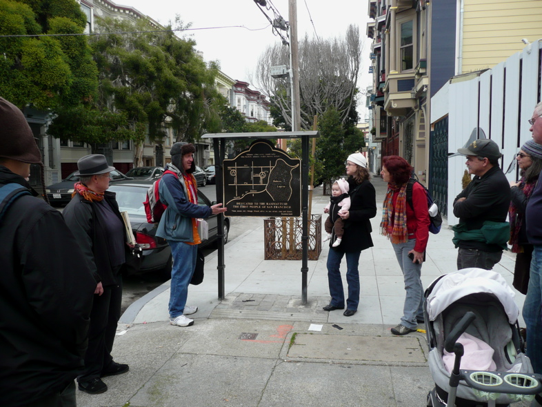
As always, I held off on canceling the tour on Tuesday. I hoped there would be a gap in the rain. I was right, but more than right, I was using a weather prediction system for local San Francisco short-term planning that I’ve now tested enough to share around. Feel free to pass the link along.
The tour ended at 2pm. At 2:20, this is how the oncoming rain looked, sweeping in from the west. Good timing!
The tour only had six people, but they all came with a can-do attitude, knowing there was a continuing chance of wet. Just as the tour began, a short drizzle gave us a moment to wonder, but then it quietly made way for a dry tour. Then, exactly as the tour ended, the drizzle started up again, this time leading into a serious rain for hours. You can see the serious rain heading into SF on this snapshot, taken from the radar website that I used, among other tools, to predict. You can also see the storm that spritzed SF just prior to the tour, drifting out past Modesto.
Often Walk the Wiggle tours attract large crowds, but being in the middle of a weekday, fewer folks were available. This can be a real treat, as it was on this occasion. Smaller groups tend to be more excitable, especially when they’re as curious and locally knowledgeable as these guys were. (I try to keep crowd size fairly low on all tours, but it can be difficult when people forget to RSVP!)
Thinkwalks, especially Wiggle walks, cover material in no particular order, because that makes it possible to keep things interesting for everyone, especially me. If I followed a sequence from an outline, it would become blah for me, which would make it blah for you. So it’s especially nice to have a very small tour like this one, where the agenda is set by something more like conversation, and less by a presentation. Often more material gets covered, but even when less gets covered (tangents, ya know), I’ve found that the knowledge retention is better.
For those of you on this tour, this blog post can act as an ongoing virtual space where you can post tour follow-up discussion using the comment reply form, below.
This post is a confession—actually a whole confessional litany. I told untruths. Yes. Me. I know, I know: never trust me again! I’ll list them in a moment so you can adjust what you learned on one of my tours accordingly.
Friend and Thinkwalks volunteer Nancy Botkin told me the other day that it’s strangely easy to change my mind about an “objective fact.” All you need to do is give me careful evidence of something that contradicts what I used to adamantly believe. I flip from saying I’m sure the Emperor was present to saying I’m not sure—or even that I was totally wrong. It’s not that I’m so easy to convince, but that information available is fuzzy and subject to interpretation.
Heck, I know, I dunno
There! You’re prepped now with a relativistic haze casting doubt on the existence of Truth itself. That makes you fully ready for my confessions.
Here’s the top stuff I’ve said that deceived The Public (you, me, etc.) on early tours. I’ve since found evidence of being so wrong.
Untruth #1 Many streams in eastern SF flowed year-round at one time.
Untruth #2 ‘San Souci’ (the creek, the valley) was from a family name.
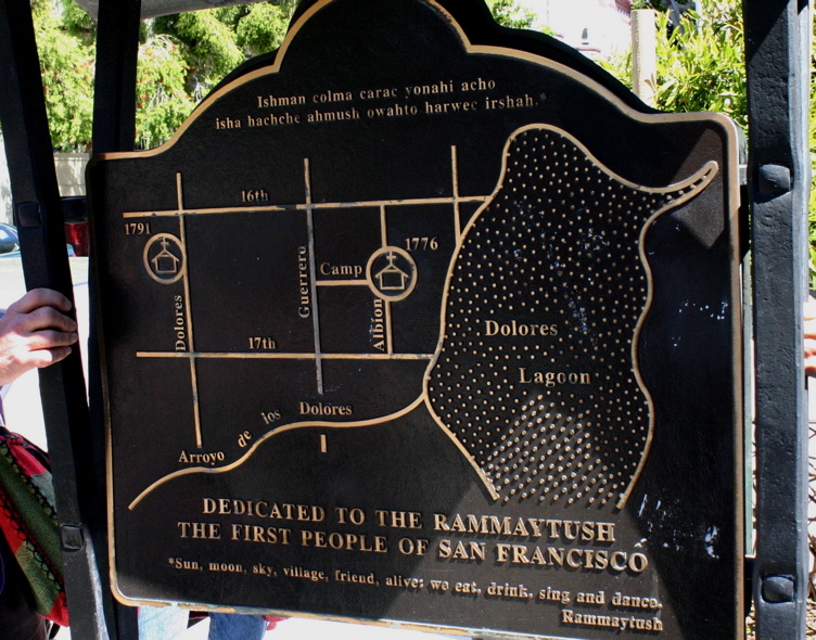
Untruth #3 The San Francisco Mission was founded at Camp and Albion.
Untruth #4 Divisadero St. was named after the nearby watershed divide (Bay to the east, Pacific to the west).
Untruth #5 Hayes Creek was never an actual surface flow.
Untruth #6 The bison in Golden Gate Park were gifts to SF from Buffalo Bill’s Wild West show.
Untruth #7 The scent added to odorless methane to make it easier to smell a leak comes from onions.
Untruth #8 Ramaytush is a language not a Ohlone Indian group name.
Untruth #9 Candy-cane-shaped poles (and various other vent poles) sticking out of the sidewalk are vents from old wells.
This is a classic vent pole shape, on the corner of 22nd & Church Streets, where Mona Caron's Botanical Mural is located. See Untruth #9.
Below are my replacement untruths (or at least incomplete unknowables).
#1 Other than in very wet years, it appears (from scarce early SF photos and maps with useful views) that San Souci Creek down 14th/15th Streets and the “Dolores” Creek down 18th Street may have been dry much of the time, though wet enough to redirect them into irrigation ditches. Mission Creek, itself a tidal lagoon, not a real creek, was probably sometimes just mud with a trickle. There’s much more to learn on this. If you’ve seen documents on it, show me!
#2 It’s coincidence that there’s such a last name as ‘San Souci’. The valley (Lower Haight, Wiggle, Panhandle) was probably named after the way-station discussed in my previous post.
#3 Despite the claims made on a bronze plaque at the corner of Camp and Albion Streets, there is little evidence of a lake in that location, and though the Mission was probably founded near there somewhere, it may have been more toward Duboce Park, or right where the Mission sits today.
#4 There’s much better evidence that Divisadero was named using the Spanish term for ‘lookout point’ (same linguistic root as “visual”), although there are only sketchy stories as to why it’s called this. It likely relates to a hilltop nearby, but old maps are very hard to read as to the precise hill.
#5 Maps from the mid 1800s show some ditches and possibly some intermittent flows from Hayes Valley across Market Street. It was most certainly a strong flow during the weeks of storms in the winter of 1861-62. At most other times, it was probably a trickle through muddy or sandy flats. And now it’s seeping through the soils.
One of many poles I had convinced myself was from an old well. This one is at the very top of Masonic Street and immediately beside the headwaters springs of a stream that went south toward the Castro District and then down 18th Street into Mission Creek.
#6 Stories of the first bison placed in the Park conflict on key points, but none of the reliable ones are about Buffalo Bill Cody. A girl bison, or cow, named Madame Sarah Bernhardt (after the notorious stage actor), and a bull called Ben Harrison (after the then President of the USA), were brought from the plains of Wyoming and Kansas, or Utah, along with a third and attempted fourth, fifth and sixth bison, depending which story you trust. The Paddock was moved from where the AIDS Grove is now. Some of the herd may be descended from Sarah.
#7 The stinky scent released by onions is allyl mercaptan (C3H6S1), while the scent used to make methane odorous is methyl mercaptan (CH3SH). DIY: Chop an onion and put it in a jar in your fridge for two days undisturbed. When you open it, you’ll smell mercaptan.
#8 Linguists group people by the way they speak. Yelamu Ohlone people in what’s now SF all spoke subset tongues of the Ramaytush language group, as did some other people in the region. As a result of this artificial grouping, many people now refer to the group of people who spoke those tongues by the language name. That usage created a meaning that represents a discernible group.
#9 It seems most of the vent poles are associated with subsurface PG&E utility vaults nearby. Others are still a mystery, but city employee Greg Braswell, who knows far more than anyone else I’ve met about the details of streets, doesn’t think they’re from wells. If you find one that’s not near a PG&E-marked metal cover, let me know and I’ll investigate.
Maps are so unreliable. Even when they are well drawn—which hilly places never were before the advent of contour lines in the 1850s—they don’t necessarily have a key telling useful details. Sometimes a map shows what a place has or had, or what the mapmaker thought was once there. All too often, though not captioned as ‘fantasy’, they tell what someone wishes to encourage into existence in the future. (“Please invest!”)
On my tours I almost always refer to the Lower Haight neighborhood and Panhandle area of San Francisco as “San Souci Valley.” That’s the name used until the 1920s or so. I started being curious about it from an old and obviously unreliable map.
This was the map I saw, showing few buildings, and making "San Souci" look nearly as important as the Mission Dolores itself. Other than misspelled French for "carefree," I had no idea what "San Souci" was. And maps of the time are little help.
This is the bizarre story of this little-used old moniker, the maps that make it fun, and discovery—yours and ongoing.
Just so you have the context, the streets through the Western Addition and Panhandle areas were graded about 1870, as a result of expansion fueled by the silver boom of the Comstock Load. Before that huge development project, the area was remote and difficult to pass through. It was windy, sandy, and generally tough going for horse or human. North of the east-west dune at Page Street, it was all truly boonies.
The 1857-59 map shows what was probably an orchard entirely filling the low spot that may have been the lake. The vertical white bars indicate the line of Divisadero Street.
But there was one spot of relief. On the line of Divisadero near Hayes, there was probably a triangular lake for a time. And on its north point, at what’s now Fulton and Divisadero, stood a refuge from the nasty wind: San Souci Roadhouse. When I first saw a map with a building (image above, right), created in 1853 by SF City Surveyor Clement Humphreys, I was merely confused. Hills marked with the old hatchers instead of contour lines were unclear and locations were inexact. On the 1851 city line (currently Divisadero St.) and on the weaving, dotted line trail from the Mission to the Presidio, stood a building. Yet another map (below) from 1861 showed property lines marked with family names, so I thought San Souci could be a name.
When I first started the Walk the Wiggle tour, I contacted a local author, Dan San Souci, hoping he’d help clear up the name’s source. He said his family wasn’t old SF stock, and he didn’t have any ideas for my search, though he took a nice photo when he came on my tour.
Thanks to the digitization of old library books, I was able to find a reference that explained the San Souci Roadhouse as the source of the name, and then I found a booklet created for Mercy Terrace (the old SP Railroad hospital at Fell and Baker) which detailed the San Souci property. This led me to the California Historical Society’s original copy of a lease from San Souci. I’ll go into that whole angle a lot more in a future post, but I do want to give you one more sweet glimpse of the roadhouse just before it was torn down in the 1920s.
Jesse Brown Cook took this photo after other buildings had encroached on the original roadhouse. Storefronts had also been added. If you know of any photos before all these changes, I'd love to hear!


")


