In the mid 1990s, I helped create two pieces of printed matter that I had no idea would hit it off one day. With each other.
Strange, but true: Stannous Flouride’s Star Map of the Haight and 409 House’s Directory of Local Services found one another, fourteen years later, and got hitched.  The resulting Haight Ashbury Map & Guide is the latest incarnation of a long history of local resource guides and maps.
Stan approached me about producing his first handmade “Star Map” of the Haight, and I helped him get the thing printed. It’s seen many versions since, and it’s now been incorporated into this new publication, thanks to Stan and the folks at Rufus Graphics, Booksmith, and Flower Power Tours.
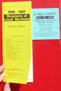
Here’s what it’s ancestor looked like in 1996. The Haight Ashbury Service Association, based at 409 Clayton, hired me to research and publish this enticing yellow “first” edition, which was itself a continuation of a long trend in free information resources about the neighborhood, begun with the Haight Ashbury Switchboard in 1967.
In 2010, the new, colorful 21-page, combined Map & Guide has a fold-out map and pages about neighborhood history, things to do, and transit, but the services section is shrunken. Perhaps that’s because times have changed for the Haight and services are minuscule now.
As another a sign of the changes, the Guide actually costs money. What a crazy idea!
Of course, we at Thinkwalks feel some attachment to the result of Jack & Gay Reineck’s hard work, so we’re, um, selling it too! Just $7 and you get a surprisingly in-depth overview of local history and fun.
Next article: Podcast of Watersheds Panel
Previous article: Laguna Honda watershed
